Potential spring flooding: St. Lazare putting faith in dykes, Moosomin builds dykes around wells
April 16, 2013, 1:58 am
Kevin Weedmark

With the potential of significant spring flooding this year the community in the area most vulnerable to flooding-St. Lazare-will be relying on a built-up dyke system to protect the community, while the town of Moosomin has built new dykes to protect its wells in the Pipestone Valley.
Martin Dupont is the mayor of St. Lazare, which is vulnerable to flooding because it sits on the valley floor at the confluence of the Assiniboine and Qu'Appelle Rivers.
He says he believes the dyke system around the village should provide protection to the majority of the village, which is on the east bank of the Assiniboine River.
There are some homes west of the river which are not protected by the dyke system.
"There are some properties along the river that could be affected if things decide to melt quickly," Dupont said Thursday. "We're feeling confident that our dyke will hold everything out on this side."
The dyke was raised in height, so it is now three feet higher than the floodwater crest in 2011-when the valley flooded and access to the village was limited.
If there is flooding this spring, the village will assist those residents with sandbags.
"We may get the school kids out and get something going," Dupont said.
He said the province's flood forecasts have been changing.
"A month ago they felt comfortable there wouldn't be much flooding, but their predictions have changed because of additional snow, and the slow melt. Now they're worried if it warms up fast there will be a quick melt and flooding."
While flooding wasn't a problem last spring, many people were worried because of rumors spread by social media, Dupont says.
"There were rumors that were brought on by people who were worried on Facebook and Twitter, getting the rumor mill going, instead of phoning and getting the facts. They were putting the fear of the Lord into people, indicating the (Shellmouth) dam was breached and the water was going down the valley. When people make their own assumptions instead of getting the facts it's always the worst-case scenario."
Dupont says the village office is getting regular flood forecast updates from the province. "We get an update every day at the town office, and it doesn't change a lot, but the people who could be concerned, we pass it on to them.
"At this point, they're predicting it could flood, it might not flood, they don't really know. We don't want to put the fear out there."
The village of St. Lazare is protected by a one kilometre dyke that runs north-south along the river that connects to the CN main line, which runs east west, protecting the community.
The village closely monitors water on both sides of the dyke.
"We have a couple of control gates on them, and we have to pump water over the dyke from the spring runoff," Dupont explains.
"We pump some of it, but not all of it, to keep the pressure the same on both sides. We wouldn't want it totally dry on one side and all that pressure on the other side. We monitor it, we watch it, and we equalize the pressure on both sides of the dyke. It really helps us."
Dupont isn't ready to place any bets on just how much flooding there will be this spring.
"Right now from what we're guessing there's still lots of snow in the bushes and we're expecting low-lying land will be flooded. Just how much we don't know. I can't really predict that-if I could the government would hire me full time," he says with a laugh."
The government isn't ready to predict when any spring flooding might crest.
"They have no idea when it will crest," says Dupont. "With this crazy weather, nothing's melting."
Moosomin works to protect wells
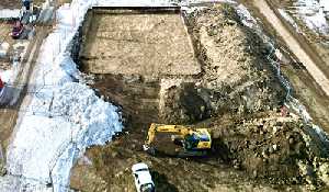
Meanwhile, the town of Moosomin has built protective dykes around the town wells in the Pipestone Valley.
The town draws its water from wells next to Moosomin Lake, and pipes it to town.
The well shacks are a few feet higher than the normal water level in Moosomin Lake, but floodwaters can affect the area.
When the flood of 2011 hit, the town protected the wells with sandbags, to prevent floodwaters from contaminating the wells.
Now, permanent three-foot clay dykes have been built at the well site to protect the town wells from potential flooding.
"We didn't want to take a chance of any flood waters contaminating the wells, and we wanted to do it now before the road bans came on," said Mayor Larry Tomlinson.
"The wells are quite a bit above the lake level, but you never know what's going to come."
The town is also monitoring the south side of Wright Road, which had water flowing over it from the field to the south in 2011.
"We're watching that closely, because we had water coming over there last time, and we've talked to Ken Turpie (the landowner) to make sure we can ditch it if we need to."